


Ministik Trail Maps and Directions to staging areas
Google Maps Trail systems - Email us if you want a copy of the Kml file to upload yourself into a GPS or Google maps
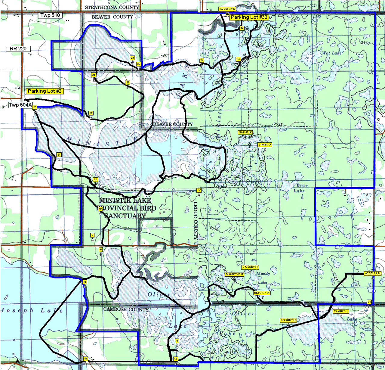
TRAIL MARKERS IDENTIFICATION
Large Yellow arrows signs are Snowmobile trails
The 4"X4" blue signs are for the horse trails ONLY
The 4"x4" Yellow signs are for the Waskihegan walking trail.. No Snowmobiles allowed on this trial, walking trails only
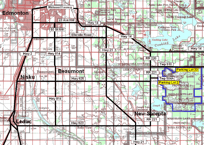
Getting there
Take any freeway east in Edmonton until you reach 1st Street (Meridian Road).
Turn to the right (south) on 1st Street (Meridian Road) and follow it until it turns east, which will now become Hwy 14 East.
Travel east bound continuing under the Camrose Hwy 21 overpass and keep going to just past the Cooking Lake Sailing Club - be aware of the range road sings about where the road bends more to the north.
Watch on the right side for the sign "Range Road 220 (RR220)" and turn right (south) down RR220 for about 3 KM.
NOTE: When you meet Township Road 510 (Twp510 is a correction road) the road will change to Range Road 221.
For Parking Lot Access #33 (North Lot) turn left (east) when you hit the intersection of Twp 510 the correction road (the road is not straight it is 15 feet to the left). Keep going (East) about 5 Km, the parking lot is on the right side.
If going east on TWP510 Parking lot #33 is just past RR212 but before RR210...
For Parking Lot Access #2 (West Lot) keep going straight ahead on RR221 past Twp 510 until you reach RR504A. Turn left (east) on Twp 504A and drive about 1.5km to the Ministik Lake Bird Sanctuary parking area Access #2, which is on the corner of Twp504A and RR215 (take the right drive way down into the parking area). This can be a popular parking area, please try to park in an organized fashion to allow more vehicles later in the day
While going south on RR220 the will take a sharp bend .. parking lot @3 is on your left..
Access #22 on the east side has NO parking. It is only a trail exiting the Sanctuary onto a county road.
Please do not stage out of the Joseph Lake campground. Please do not park on the main road or any of oil service roads as they are used by heavy trucks daily. The campground gate is closed and we have no permission to stage from anywhere near there.
General Info
The Sanctuary is about 8.5Km by 8.5Km square or about 75Km square of snowmobiling with about 60Km of marked trails.
The trails range from lakes, meadows, bush, hills and creek beds.
There are lots of Deer, Moose, coyotes and various range birds
Ministik Trail system is east of Edmonton between RR215 and RR209, and 3 miles south of Hwy 14. That's what makes it so attractive is it is only 20 minutes from Edmonton. Tri-County and the Fort Saskatchewan Snowmobile Clubs all work to maintain these trails.
Ministik:
Tri-County operates and maintains the trail system at Ministik (East of Edmonton). Click hear for directions and map
If you have any questions, suggestions or concerns about trails please click here to send us an email.
For a complete Alberta trail listing:https://www.tri-county-snowmobile.com/